Project
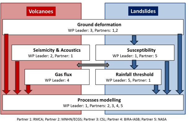
RESIST combines ground- and spaceborne techniques to study two major hazards affecting the Kivu Basin region using both transversal and exclusive methods:
Ground deformations (transversal)
Ground deformation measurements and monitoring are achieved for both fields addressed within the RESIST project.
- Ground based methods: geodetic GPS network.
- Spaceborne methods: advanced SAR interferometry (DInSAR, SBInSAR, SBAS, MSBAS) and VHSR optical data analysis (e.g. Pleiades).
- These techniques will be complemented by field observations.
Seismic and infrasound characterization
- Installation and maintenance of the seismic and infrasound network.
- Data collection and sharing protocol.
- Signal processing of the acquired datasets.
SO2 Gas flux
- Measurements of SO2 emissions by volcanoes in the Kivu rift zone.
- Creation of a unique long-term consolidated dataset of SO2 flux for the volcanoes in Congo. This is achieved by a combination of satellite instruments (from ongoing and future missions with improved signal-to-noise and spatial resolution).
- UV camera deployed on the ground.
Landslide processes and spatiotemporal characterization
- Inventory of the landslides and the prediction of their spatial occurrence (susceptibility).
- Study of the environmental factors explaining their occurrence.
- Identification of rainfall thresholds for the different landslide types.
- Usage of TRMM (Tropical Rainfall Measuring Mission) data, and once available, the GPM (Global Precipitation Measurement) mission data.
Process modelling (transversal)
- Assessment of the physical processes and mechanisms underlying pre-eruptive activity of the volcanoes in the VVP and landslide mechanisms.
- The proper characterization of the mechanisms related to dyke intrusions and/or volcanic eruptions in the VVP will contribute to improve our understanding of the not well known continental rifting process at its early stage. The proper identification and characterization of the pre-eruptive processes can eventually contribute to the aim of eruption forecasting.
- Assessment of the landslide mechanisms in order to anticipate their future occurrence according to rainfall distribution. The different processes will be analysed according to their spatiotemporal occurrence.