Landslides impacts are high in less developed countries, particularly in tropical areas where a combination of active tectonics, steep topography, intense rainfall and high population density is found. This is a combination that is observed in many places over the Kivu Rift (RDC, Rwanda, Burundi), the landslide-prone region where both RESIST and MODUS focus. In the framework of the mother RESIST project, the study of landslides in this region was initiated in a first approach with the aim to create a regional landslide inventory, to characterize the leading processes, and to explore the effect of rainfall on ground displacements and on landslide initiation. MODUS aims to go a step further into the characterisation of the landslides processes affecting the region, with a special focus on the city of Bukavu (DR Congo). To reach these aims, the techniques used within RESIST will be applied using additional image acquisitions allowing to extent deformation time series but these measures will, in addition, be confronted to results obtained from new techniques such as optical images correlation or terrestrial laser scanner.
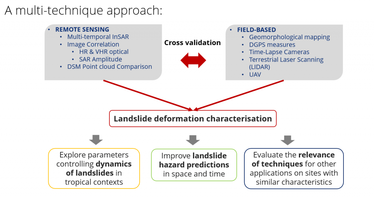
The series of remote sensing techniques - ranging from ground-based close-range to spaceborne techniques - that will be employed, will, for instance, serve to the measure of the ground surface velocity fields over the area. The analysis of the latter will provide an essential piece of information to better define the parameters that are controlling the dynamics of landslides in the region, an analysis that is useful for both scientific and hazard-related purpose. To reach this goal, a multitemporal, multiscale and multi-sensor study will be built, the latter being needed to characterise the signature of distinct parameters, with various range of temporal variability and ground surface parameters.
The city of Bukavu counts currently ~800 000 inhabitants but is characterized by a rapid uncontrolled expansion. The continuously moving landslides are there responsible for a continuous degradation and destruction of houses, buildings and roads, but also of the water networks and sewerage infrastructures in several districts of the town.
The methods that will be developed in MODUS will allow a better detection and delineation of the landslides affecting Bukavu, contributing to the update of the landslide inventory that serves as a basis for the assessment of the landslide susceptibility, hazard, and risk. In the long term, these products are essential to identify suitable strategies to mitigate the negative impacts of these mass movements. The knowledge acquired with this project could thus be transposed to understand processes and develop mitigation strategies also for landslide affecting other cities of the tropics, many facing similar problematics such as slope instabilities, urban sprawl and poverty.
A focus is set on two key landslides (Funu (a) and Ikoma (b)) situated in the region of Bukavu. Located within 10 km of one another, the characteristics of these large, slow-moving deep-seated landslides contrast in many ways (e.g., age, degree of anthropic influence, deformation velocity, etc.), making them characteristic ‘end-members’ while sharing natural environmental conditions. By a study of their mechanisms and responses to external trigger of instability, we intend to answer the following research questions:
- What are the causes and drivers of slope instability in this tropical context? Are specific tropical conditions linked to landslide behaviour?
- Are landslides developing age-related responses to external forcings?
- Can we identify human-induced stress perturbations in their evolution?
- How do landslides evolve and how far can we predict their future behaviour?
- What are the most effective (remote sensing) methods (or combination of) to study the current (and past) dynamics of landslides in such a data-scarce context?
![]()